Master Index Nearest Caches Canal de Nantes ŕ Brest - Le barrage de Guerlédan by janpe (2/2,5)
N48° 11.607 W3° 01.005 (WGS84) UTM 30U E 498755 N 5337802 Use waypoint: GCVYRB Size:  Regular Hidden on 25-04-2007 Regular Hidden on 25-04-2007
In Côtes-d'Armor Bretagne, France Difficulty:  Terrain: Terrain: 
*No attributes specified* Add cache to watch list Log your visit Picture Gallery |
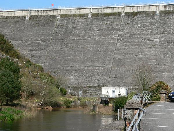
| Le barrage de Guerlédan est une centrale hydroélectrique située sur
les communes de Saint Aignan dans le Morbihan et de Műr-de-Bretagne
dans les Côtes-d'Armor. The Guerlédan Dam is a hydroelectric power station located between the communes of Saint Aignan in Morbihan and Műr-de-Bretagne in Côtes-d'Armor. |
Au début du 20eme sičcle, le canal de Nantes ŕ Brest perd de son importance et de son utilité. Les espoirs de développement se tournent alors vers une nouvelle source d'énergie : " la houille blanche ", c'est ŕ dire l'énergie hydroélectrique.
A partir de 1922, on construit un barrage et une usine hydroélectrique, qui retiendront les eaux venant de la vallée du Haut Blavet. Ces deux ouvrages sont inaugurés le 12 septembre 1930.
Avec ses 45 mčtres de hauteur et ses 206 mčtres de longueur de cręte, le barrage de Guerlédan retient une réserve de 55 millions de mčtre cube d'eau sur une étendue de 400 hectares.
La mise en eau de la retenue de Guerlédan a engloutie plus de 12 km de la vallée du Haut Blavet. Tous les 10 ans, lors de la vidange du lac, on peut découvrir, telle la ville d'Ys engloutie, l'ancienne vallée, avec ses maisons éclusičres, son halage, ses jardinets, ses écluses et déversoirs!
A l'origine, le projet prévoyait la construction d'une échelle d'écluses en parallčle au barrage afin de maintenir la navigation sur cette voie d'eau. Cette initiative n'a jamais aboutit, divisant ainsi le canal de Nantes ŕ Brest en deux tronçons de navigations : ŕ l'Ouest, la branche finistérienne et ŕ l'Est, la branche Loire Atlantique et morbihannaise.
Par ses dimensions, le Lac de Guerlédan est le plus grand lac artificiel de Bretagne. Ouvrage industriel, le lac a su apprivoiser les éléments qui l'entoure et offre aujourd'hui de multiples facettes ainsi que des activités diverses au goűt de chacun.
At the beginning of the 20th century, the Nantes to Brest canal diminished in importance and its usefulness. The new hope was the development the new source of energy: “white oil”, i.e. hydroelectric energy.
In 1922, a dam and hydroelectric power station were built retaining water coming from the valley of upper Blavet. These two structures were inaugurated on September 12, 1930. At 45 meters high and its 206 meters long (at the top), the Guerlédan dam retains 55 million cubic meter of water and covers 400 hectares.
The Guerlédan lake absorbed more than 12 km of the valley of the upper Blavet. Every 10 years, when the lake is drained, you can discover, the town of Ys, and the old valley, with its locks, lock-keepers cottages, tow path etc submerged by the lake.
Originally it was envisaged that a flight of locks would be built at the same time as the dam in order to maintain navigation on the canal. However they were never constructed, thus dividing the Nantes to Brest canal into two sections the Western Finistere branch and the Eastern, the Morbihan and Loire Atlantique branch.
The Guerlédan Lake is the largest artificial lake in Brittany. The construction of the dam tamed the force of the water and the lake now offers a variety of activities to suit everyone.
Additional Waypoints
PKVYRB - ParkingN 48° 11.571 W 003° 01.181
Additional Waypoints (1)
| Code | Name | Type | Links | Comments | Date | Coordinates | Distance |
| PKVYRB | Parking | Parking Area | Google Maps | 25-04-2007 | N 48° 11.571 W 3° 01.181 | 0,23 kms W |
Additional Hints (There are no hints for this cache)
Current at 24-06-2010
![]() 13-05-2010 by Yannis52
13-05-2010 by Yannis52
Found it during a short holiday in Bretagne. Nice view after steep climb. Cache was easy to find.
Thanks for bringing us here.
NINO
Yannis52
![]() 20-04-2010 by janpe
20-04-2010 by janpe
I' sorry that the cache box is rather damp. I will be returning to Britttany in a few weeks and will replace the box and log book
![]() 14-04-2010 by gulacache
14-04-2010 by gulacache
Superbe point de vue sur la retenue d'eau et sur le barrage !!!
Par contre le contenu de la cache est trčs humide ...
In : pičce de monnaie turque
TFTC
![]() 12-04-2010 by spinz
12-04-2010 by spinz
C'est ŕ la deuxičme tentative avec un GPS que j'ai pu trouver cette cache qui offre un splendide panorama sur le lac.
Cache humide.
![]() 23-03-2010 by zitronenjette
23-03-2010 by zitronenjette
N48° 11.607 W3° 01.005
We were two months on cache-tour, found it on the way down France, Spain and Portuguese . Many thanks for the cache and for showing this lacation! Kind regards from Hamburg/Germany
Nearby Caches
GC19FPT
GCTNMH
GC19MB2 Canal de Nantes ŕ Brest - Notre Dame de (9,28 kms S)
GC19GH0 Canal de Nantes ŕ Brest - Etangs du Roz (11,33 kms SE)
GC1HQH1 La Chapelle de Rosquelfen (11,35 kms W)
Additional Hints (There are no hints for this cache)