Master Index Nearest Caches Canal de Nantes ŕ Brest - Notre Dame de Carmčs by janpe (2/2)
N48° 06.717 W2° 59.355 (WGS84) UTM 30U E 500800 N 5328743 Use waypoint: GC19MB2 Size:  Small Hidden on 06-04-2008 Small Hidden on 06-04-2008
In Morbihan Bretagne, France Difficulty:  Terrain: Terrain:
*No attributes specified* Add cache to watch list Log your visit Picture Gallery |
| La commune de Neulliac est placée au nord de la ville de Pontivy.
Le petit village de Carmčs vous attend au bord de la départementale
767 ŕ environ 4 km de Pontivy et 2 km du bourg de Neulliac. The commune of Neulliac is located north of the city of Pontivy. The hamlet of Carmčs is on the minor road (D756) 4km North of Pontivy 2 km from the town of Neulliac. |
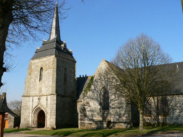
De la chapelle reconstruite au XVčme sičcle subsistent la nef qui portrait ŕ l’origine un clocheton charpenté et le transept. Au debut du XVIčme sičcle, le seigneur du Porzo fait edifier la tour de clocher et son porche.
Les travaux de restauration entrepis en 1983 ont permis la découverte, sous les lambris peints en 1705 par La Palme, de la charpente ancienne ŕ chevrons formant fermes et cerces moulurées polychromes et dans le transept, d’autres lambris peints d’une qualité exceptionnelle de la fin du XVčme sičcle, représentant des scenes de la vie de sainte Catherine. De cette époque datent aussi les peintures murales mises ŕ jour dans la nef, et celles conserves derričre le retable sud.
Les toiles du choeur ont, elles, été peintes en 1772, par Déduy aprčs le rallongement de l’édifice et construction de la sacristie en 1768. Les retables, poses au XVIIIčme sičcle, ont été restaurés en 1809 par Blévin.
Le calvaire, édifiéen 1759, fut offert par Louis Audren et Marie Bernard. La fontaine, située ŕ une centaine de metres au nord de la chapelle, date de la fin du XVIIIčme sičcle.
La date découpée dans la pierre au-dessus de la fontaine est ABCD (La date n'est pas facile ŕ lire. Checksum A+B+C+D = 19)et la cache se trouve ŕ
N48 06.(A+B)(C+A)(C-A) W002 59.(D)(B-D)(C+A)
N'essayez pas de rallier la cache depuis la fontaine, ŕ pied et en ligne droite. La bonne option consiste ŕ revenir au waypoint PK (parking prčs du canal) aprčs avoir visité la fontaine.
The nave, which originally had a wooden turret, as well as the transept date from the chapel’s reconstruction in the XVth century. In the early XVIth. century, the Lord of Porzo had the church tower and porch built.
While the chapel was being restored in 1938 the original roof timbers with their polychrome carvings were discovered behind the wooden panelling which was decorated by La Palme in 1705. In the transept, the fabulous paintings on the wooden panelling of exceptional quality, represent several episodes in the life of Saint Catherine. The mural paintings in the nave also date from the XVth century but don’t forget the paintings behind the southern reredos (screen behind the altar).
The canvases in the chancel were painted in 1772 by Déduy after the extension of the building and the construction of the sacristy in 1768. The reredoses dating from the XVIIIth century were restored in 1809 by Blévin.
The calvary put up in 1759 was donated bt Louis Audren and Marie Bernard. The fountain, a hundred metres North of the chapel, dates from the end of the XVIIIth century.
The date carved into the stone above the fountain is ABCD (The date isn't easy to read. Checksum A+B+C+D = 19) and the cache lies at
N48 06.(A+B)(C+A)(C-A) W002 59.(D)(B-D)(C+A)
Don't try to get from the fountain to the cache on foot in a direct line (following the arrow). The best way to get to the cache is to go to the parking waypoint near the canal after visiting the fountain, then follow the tow-path.
Additional Waypoints
FT19MB2 - la fontaineN 48° 06.823 W 002° 59.396
La date découpée dans la pierre au-dessus de la fontaine est ABCD
PK19MB2 - Parking by Canal
N 48° 06.841 W 002° 59.735
Parking by canal and Porzo pumping station for the 'rigole d'Hilvern'
Additional Waypoints (2)
| Code | Name | Type | Links | Comments | Date | Coordinates | Distance |
| FT19MB2 | la fontaine | Question to Answer | Google Maps | La date découpée dans la pierre au-dessus de la fontaine est ABCD | 06-04-2008 | N 48° 06.823 W 2° 59.396 | 0,20 kms N |
| PK19MB2 | Parking by Canal | Parking Area | Google Maps | Parking by canal and Porzo pumping station for the 'rigole d'Hilvern' | 06-04-2008 | N 48° 06.841 W 2° 59.735 | 0,52 kms NW |
Current at 24-06-2010
![]() 09-08-2009 by MereDamien
09-08-2009 by MereDamien
As I stayed in Pontivy, Notre Dame de Carmčs (and it's cache), was a nice target for a walk in the neighborhood.
Thanks janpe for this cache!
![]() 19-05-2009 by STEPHANE29
19-05-2009 by STEPHANE29
pas trouvé snif, snif
![]() 13-04-2009 by bulo
13-04-2009 by bulo
Magnifique chapelle (exterieurs), et jolie fontaine.
Le site est reposant.
La balade ensuite, le long du canal est agréable également.
Nota1: la chapelle est fermée jusqu'ŕ la fin des travaux (date non précisée)
Nota2: Il y a plein d'arbres susceptibles de receler une cachette.
bulo
![]() 15-03-2009 by aero30
15-03-2009 by aero30
Petite multi facile et dans un cadre agréable. Merci Janpe
Décidemment la bretagne regorge de trésors et les idées de caches sont inépuisables.
![]() 25-02-2009 by paskall
25-02-2009 by paskall
Trouvée par une belle journée ensoleillée, avec mes filles.
Out 5 cts de Franc et une petite voiture de course
In 1 ancien Franc et une petite voiture.
Appareil photo encore oublié....
Nearby Caches
GC19GH0 Canal de Nantes ŕ Brest - Etangs du Roz (4,03 kms E)
GCVYRB Canal de Nantes ŕ Brest - Le barrage de (9,28 kms N)
GC1FCYB Shepherd's spring (9,95 kms S)
GCTJPQ Canal de Nante ŕ Brest - Rigole d’Hilver (11,67 kms E)
GCRVYA Canal de Nante ŕ Brest-Echelle d’écluses (11,72 kms E)
Hints (Back)
Au pied d'un grand arbre. At the base of a large tree.