Master Index Nearest Caches Le cinquieme hauban by bob29 (2/2)
N48° 20.570 W4° 37.370 (WGS84) UTM 30U E 379750 N 5355678 Use waypoint: GC14Y7G Size:  Regular Hidden on 05-08-2007 Regular Hidden on 05-08-2007
In Finistčre Bretagne, France Difficulty:  Terrain: Terrain:
*No attributes specified* Add cache to watch list Log your visit Picture Gallery |
 |
Le cinquičme hauban
Ne vous rendez pas aux coordonnées indiquées plus haut, ELLES SONT FICTIVES. Il ne vous manque que les 3 derniers chiffres de chaque coordonnée.
Le petit tableau ci-dessous vous aidera ŕ les obtenir.
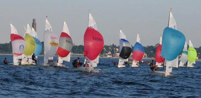
Facile, il faut trouver le nom français ou anglais (c'est identique) de l'objet figurant sur la photo, selon la plus simple expression connue.
Il s’agit d’une voile d'avant trčs légčre et trčs creuse hissée aux allures portantes. (9 lettres)
Une fois trouvé, il vous suffira de le décrypter selon la clef de décryptage suivante :
A=0, B=1, C=2, D=3, E=4, F=5, G=6, H=7, I=8, J=9, K=0, L=1, M=2, N=3, O=4, P=5, Q=6, R=7, S=8, T=9, U=0, V=1, W=2, X=3, Y=4, Z=5
Cette série de chiffres formera un nombre qui devra ętre utilisé comme suit :
Au nombre formé par les 3 premiers chiffres, RETRANCHER 402, vous obtiendrez ainsi les 3 décimales des coordonnées Nord.
Au nombre formé par les 3 derniers chiffres, AJOUTER 673, vous obtiendrez ainsi les 3 décimales des coordonnées Ouest.
Vous pouvez vérifier l'exactitude des coordonnées ici :Geochecker.com.
Conseils: Stationnez votre véhicule en 48 20.505N – 04 37.580W
Utilisez la route qui monte et longez des bâtiments que vous laissez sur votre droite puis suivez les conseils du GPS.
La géocache est située (dans un rayon d’un mčtre) sous ce vieux systčme d’attache d’un cinquičme hauban aujourd’hui disparu.
De cet endroit, par temps dégagé, vous disposez d’une vue époustouflante sur la mer d’ Iroise.
De męme, ŕ droite vous pouvez voir la GCZVJA et sur la gauche la GC10X0C. Alors Osez ! Bon geocaching.
The fifth stay
Don't go to the coordinates indicated higher, THEY ARE FICTITIOUS. You miss only the 3 last figures of each coordinates.
Below, the small table will help you to obtain them.
Easy, you have to find the French or English name (it is the same) of the object reproduced on the photograph, according to the simplest known expression.
Is a special type of sail that is designed specifically for sailing off the wind from a reaching course to a downwind. (9 letters)
Once found, it will be enough for you to decipher it according to the following key of decoding:
A=0, B=1, C=2, D=3, E=4, F=5, G=6, H=7, I=8, J=9, K=0, L=1, M=2, N=3, O=4, P=5, Q=6, R=7, S=8, T=9, U=0, V=1, W=2, X=3, Y=4, Z=5
This series of figures will form a number which will have to be used as follows:
With the number formed by the first 3 figures, CUT (-) 402, you will thus obtain the 3 decimals of the North coordinates.
With the number formed by the last 3 figures, ADD (+) 673, you will thus obtain the 3 decimals of the Western coordinates
You can check your answers for this puzzle on Geochecker.com.
Instructions : Station your vehicle in 48 20.505N - 04 37.580W
Use the road which goes up and skirt buildings on your line then take the advice of the GPS.
The géocache is located (in a radius of one meter) under this old system of fastener of a fifth stay now disappeared.
Of this place, by good weather, you will have a superb sight on the sea of Iroise.
On the right you can see the GCZVJA and on the left the GC10X0C. Then Dare!
Excuse me because I maitrise not perfectly the English language. Good geocaching.
Additional Waypoints
P114Y7G - Point 1N 48° 20.505 W 004° 37.580
P214Y7G - The cache
N/S __ ° __ . ___ W/E ___ ° __ . ___
Additional Waypoints (1)
| Code | Name | Type | Links | Comments | Date | Coordinates | Distance |
| P114Y7G | Point 1 | Parking Area | Google Maps | 05-08-2007 | N 48° 20.505 W 4° 37.580 | 0,29 kms SW |
Current at 24-06-2010
![]() 16-06-2010 by saverne54
16-06-2010 by saverne54
Des soldats s’entrainent ŕ une évacuation sanitaire ŕ deux mčtres de la cache. Merci pour le coin et cette superbe vue.
![]() 03-06-2010 by Team MiTiKa
03-06-2010 by Team MiTiKa
#15 during our holiday in Brittany
The third one on today's tour from Porsmilin to Le Fort Minou on GR 34
This was our first mystery cache in France.
Excellent hiding place, we had to search a bit to locate the cache - Mischa had the right idea where to look for it.
The view on this spot is marvellous, we took a rest here.
The remnants from WW2 give the place a creepy atmosphere, but it's softened by the graffitti.
The soldiers exercising nearby where adding to it.
TFTC
Team MiTiKa & Samba
![]() 28-03-2010 by vince29
28-03-2010 by vince29
Du parking,deux possibilités s'offrent ŕ nous, une nous mčne ŕ la cache en 100 m, l'autre nous fait faire un grand tour, devinez celle que nous avons choisie sous la pluie...
![]() 25-02-2010 by TYGWEN
25-02-2010 by TYGWEN
Beau site un peu froid et humide...
TFTC
in livre spirou
out requin
![]() 05-02-2010 by bobichon41
05-02-2010 by bobichon41
Trouvé ŕ 12 h 05 .Je suis retourné ŕ la voiture prendre l'appareil photo tant l'endroit mérite d'ętre mitraillé.
In: rien
Out: rien
Nearby Caches
GC10X0C Le Minou (0,80 kms SE)
GC20XZ6 Pins maritimes (1,29 kms E)
GCZVJA Le vieux moulin des landes d'iroise (2,21 kms W)
GC241QE Le châtaignier de la ribine. (2,82 kms NE)
GC14JZ1 Bruyčres et ajoncs (2,95 kms E)
Hints (Back)
Suivez ce doigt qui montre le ciel. Follow this finger which shows the sky.