Master Index Nearest Caches Bruyčres et ajoncs by bob29 (2/2)
N48° 20.900 W4° 35.025 (WGS84) UTM 30U E 382659 N 5356229 Use waypoint: GC14JZ1 Size:  Regular Hidden on 23-07-2007 Regular Hidden on 23-07-2007
In Finistčre Bretagne, France Difficulty:  Terrain: Terrain:
*No attributes specified* Add cache to watch list Log your visit Picture Gallery |
 |
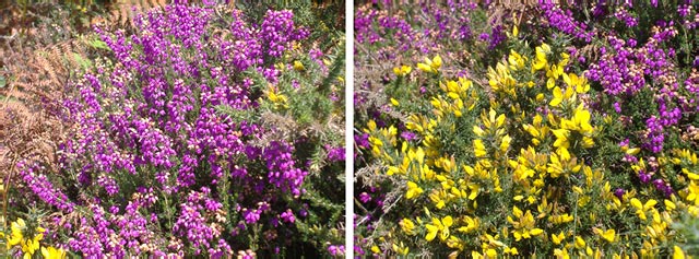
Voici deux des plantes des plus typiques de la lande bretonne.
Vous pourrez les admirer lors de la découverte de cette geocache.
J’espčre pour vous que vous aurez la chance de les voir en fleurs : Evidemment cela dépendra de la période de votre visite.
Vous remarquerez également le chčvrefeuille, la fougčre, le genęt, et bien d’autres choses ….
Et…… surprise, une construction surprenante et étrange…..Je vous laisse découvrir…. (voir lien page web en haut du listing)
Cette petite promenade bucolique peut ętre abrégée en allant directement au wp3 mais c’est plus difficile pour stationner votre véhicule.
Bon geocaching
Here two of the plants of most typical of the the wild ground of Brittany.
You will be able to admire them at the time of discovered of this geocache.
I hope for you that you will have the chance to see them in flowers: Obviously that will depend on the period of your visit.
You will also notice chčvrefeuille, the fern, the broom, and many other things….
And ...... surprised, a surprising and strange construction ..... I let to you discover….(to see bond Web page in top of the listing)
This small bucolic walk can be shortened while going directly to the wp3 but it is difficult to station your vehicle.
Good geocaching
Excuse me because I maitrise not the English language. You can correct me by messages.
Additional Waypoints
P114JZ1 - ParkingN 48° 20.846 W 004° 35.331
Parking. Car parc
P214JZ1 - Début sentier.
N 48° 20.887 W 004° 35.386
Suivre le sentier ŕ droite (GR34).To follow path GR34 on the right.
P314JZ1 - Porte verte. Green door.
N 48° 20.940 W 004° 35.237
Longer la porte et suivre le mur, rester sur le sentier. To skirt the door and to follow the wall, to remain on the path.
P414JZ1 - La geocache
N 48° 20.900 W 004° 35.026
La geocache. the geocache
Additional Waypoints (4)
| Code | Name | Type | Links | Comments | Date | Coordinates | Distance |
| P114JZ1 | Parking | Parking Area | Google Maps | Parking. Car parc | 23-07-2007 | N 48° 20.846 W 4° 35.331 | 0,39 kms W |
| P214JZ1 | Début sentier. | Reference Point | Google Maps | Suivre le sentier ŕ droite (GR34).To follow path GR34 on the right. | 23-07-2007 | N 48° 20.887 W 4° 35.386 | 0,45 kms W |
| P314JZ1 | Porte verte. Green door. | Reference Point | Google Maps | Longer la porte et suivre le mur, rester sur le sentier. To skirt the door and to follow the wall, to remain on the path. | 23-07-2007 | N 48° 20.940 W 4° 35.237 | 0,27 kms W |
| P414JZ1 | La geocache | Final Location | Google Maps | La geocache. the geocache | 23-07-2007 | N 48° 20.900 W 4° 35.026 | 0,00 kms W |
Current at 24-06-2010
![]() 16-06-2010 by saverne54
16-06-2010 by saverne54
Descente agréable pour rejoindre la cache (mince il y a le retour). La construction surprend effectivement (je n’avais pas lu la page web), je croyais que c’était un camp de vacance militaire avec des jeux et un toboggan géant. Merci pour la cache.
In : lion
Out : talkie walkie (pour écouter les militaires)
![]() 11-06-2010 by Team MiTiKa
11-06-2010 by Team MiTiKa
#30 during our holiday in Brittany
Another nice place along GR 34 - we very much liked this part of the GR 34, because it really offers a vast variety of landscape, and we also liked the path going up and down. 
TFTC
Team MiTiKa + Samba
![]() 20-04-2010 by yandens
20-04-2010 by yandens
Ce sera l'avant-derničre cache de la journée sous ce beau soleil...
Encore une magnifique vue grâce ŕ Bob29...
Merci pour cette belle découverte.
In & Out : notre GC Lou-Ann
![]() 11-04-2010 by lesgratineurs
11-04-2010 by lesgratineurs
Poursuite de la ballade, et hop une de plus, toujours sous ce magnifique soleil Breton.
TFTC Bob29 
IN=Voiture friction
OUT=Kermit la grenouille
![]() 24-03-2010 by famille-le-couls-29
24-03-2010 by famille-le-couls-29
Merci pour cette cache ou la vue est superbe !
In: galet décoré et stylo bille (enfin, ce qu'il en reste...mais il fonctionne ! )
Out: un calot et un carte pokémon
Nearby Caches
GC24HJX Entre le fort, la bruyere et les ajoncs: (0,17 kms E)
GC1TZ3W
GC10V8C Le goulet (1,29 kms NE)
GC241QE Le châtaignier de la ribine. (1,74 kms NW)
GC20XZ6 Pins maritimes (1,95 kms SW)
Hints (Back)
Suivez le sentier (GR 34)puis c'est entre le sol et du béton.
Follow the path (GR. 34) then it is between the ground and of the concrete.