Master Index Nearest Caches The Granite of Carnac by Les Datenkaros (1,5/1,5)
N47° 35.515 W3° 05.161 (WGS84) UTM 30T E 493533 N 5270949 Use waypoint: GC2178E Size:  Not chosen Hidden on 20-11-2009 Not chosen Hidden on 20-11-2009
In Morbihan Bretagne, France Difficulty:  Terrain: Terrain:
*No attributes specified* Add cache to watch list Log your visit Picture Gallery |
The Datenkaros introduce: The Alignements at Ménec
Les Datenkaros vous introduisent aux Alignements du Ménec
Datenkaros präsentieren: Die Steinreihen von Ménec
The Alignements at Ménec
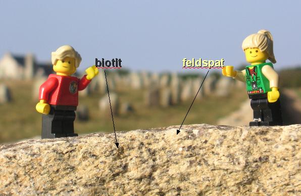
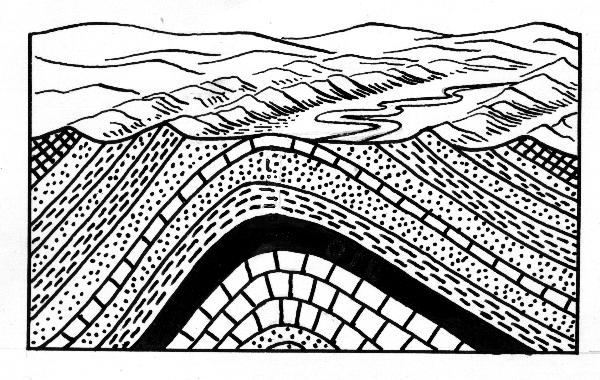
In and around the municipality of Carnac in Brittany, the largest groups of standing stones in the world are to be found. More than 3000 menhirs (Breton for "long stone") have been erected during the prehistoric Neolithic Period, between the 5th and the 3rd millenium B.C. Due to the lack of datable material (like wood, datable by C14 decay, or ceramic shards, datable by thermoluminescence), it was often not yet possible to determine a more exact date. However, it is estimated that the activities peaked around 3300 B.C. The largest sets of stone rows, or alignments, are those of Ménec, Kermario and Kerlescan just north of Carnac. The westernmost of these is the alignment of Ménec, named after the nearby village (some buildings of which were erected even within the stone rows). It contains 1099 standing stones forming 11 rows over a length of 950 m. The south-west end of the alignment is marked by a stone circle (Cromlech), which nowadays consists of 71 closely set blocks. The highest menhirs are found in the west of the alignments, among them the „Giant of Ménec“ which is 3.5 m high and was likely erected a long time before the surrounding stones. In contrast, the standing stones at the eastern end of the alignment are often not higher than 65 cm above the ground. The standing stones are composed of granite from the local massif known as the “Anticline of Cornwall”, named likewise because of its extension over the Channel to Cornwall. The geological term “anticline” describes a convex fold, in the centre of which the oldest rocks are coming to the surface.
 |
 |
| Schematic of an anticline | The Variscan fold |
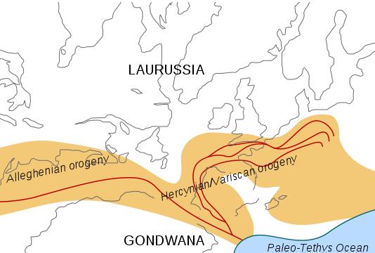
The anticline is a part of the Variscan fold, a long mountain chain that formed during the geological periods of the Carboniferous and Permian (400-300 million years ago), when the continents Gondwana (composed mainly from today’s Africa, South America, India and Australia) et Laurentia-Baltica (composed from today’s Europe and North America) collided to form the super-continent Pangea. Mountains formed at this time can be found in Bohemia, Southern Germany, Belgium, the Bretagne, and on the other side of the Channel in Cornwall and Southern Ireland. Even on the other side of the Atlantic, this ancient mountain chain continues with the Appalachian Mountains.
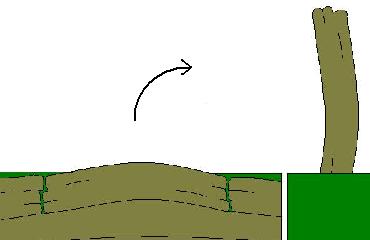
Over time, this ancient mountain chain has been largely eroded, but a remainder of the fold is the outcropping of the granite, normally a rock formed and found deeply inside the earth’s crust. Granite is an igneous rock, which means it forms by the cooling of magma (molten rocks containing different minerals), which happens between 2 to 50 km deep in the earth’s crust. Because of their high melting point, minerals like biotites, which are dark and heavy, are the first to crystallize when the magma cools. Later, minerals like quartz and feldspars crystallize, and these are characterized by a lower density, and a brighter colour. For this reason, one can see with the naked eye that the granite contains crystals of different minerals. The rocks forming the stone rows are composed mainly of potassium-rich alkali feldspar, which forms bright grains of a few millimetres diameter, and biotite, forming darker grains (Fig. 1). A part of the blocks erected as standing stones were formed by natural processes: during the solidification of the granite, vertical cracks are formed. If the rock is at or close to the surface, it is exposed to weathering, and this leads to the formation of additional cracks, this time in horizontal direction, parallel to the graining. In this way, rock plates are formed with a length and depth of up to a few meters (Fig. 4). For the construction of megalithic monuments, some of these free rocks were “just” picked up, while others had to be separated from their bedrock using wedges and levers. Some of the rocks were transported over several kilometres using rolls, tree trunks and ropes, before they were erected in a pit, perhaps with the help of rope pulling devices. Several hypotheses exist about the function of the stone alignments. The alignments of Carnac seem to be parallel to the coastline at the time of their construction. Also, they seem to be oriented towards the cardinal points, and usually end in a stone circle (“Cromlech”) at their western and eastern end. One hypothesis by Alexander Thom states that the principal axis for the alignment of Kerlescan corresponds to the east-western direction, and, when viewed from the centre, borders of the stone circle seem to correspond to the solstices of summer and winter. From this, it seems to be possible that the alignments might have had some function as an astronomic calendar, as has been shown for the stone circles of Stonehenge in England.
The stone rows are nowadays surrounded by a fence, and between April and October, they are only accessible within a guided tour organised by the Maison des Mégalithes. In the winter months, they are freely accessible between 9 AM and 5 PM. It is possible to answer the questions without entering the fenced area.
a) Enter the western stone circle of Ménec (next to the cręperie). At the rock at N 47° 35.515' W3° 05.161', you can see some traces of erosion. In which direction has the spalling of the rock occurred? What does this suggest about the orientation of the rock when it was found thousands of years ago?
b) Go to the large, nearly cuboid menhir at N47° 35.531' W3° 05.122', directly behind the enclosure. - Estimate the thickness of the block, which should correspond to the thickness of the rock layer separated from the bedrock by erosion. - Estimate the mass of the rock! A bit of research is necessary. - Look at the regions of the rock, where it has been freshly scaled off. The eroding granite is of which colour? Which chemical element is responsible for this colour?
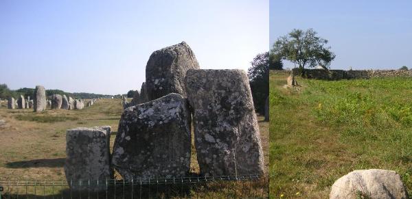
c) Estimate the distance between these three menhirs at the easternmost end of the stone circle (left) and this little menhir (right) behind the eastern wall of the alignment, near the road.
d) Upload a photograph showing you, and/or your avatars and/or GPSr at the alignments.
Additional Wayponts: More information
about the stone rows around Carnac can be found at La maison des
mégalithes, Le Ménec, 56340 Carnac, parking is also possible
there.
If you like granite, more can be found at Place de la Concorde
(GC1MN5Y), and at the Côte du Granite Rose (GC1V4YY, GC1XQEW). We
also highly recommend searching for geocaches nearby, in particular
“Menhirs et Dolmens autour d'Erdeven“ (GC1Q2RH).
Les alignements du Ménec
Dans la commune de Carnac, se trouve le plus grand groupe de megalithes au monde. Plus de 3000 menhirs (expression en breton pour «pierre longue») ont été erigées dans la periode du néolithique, entre le 5čme et le 3čme millénaire a.c. Faute du materiel datable, il n'était pas possible de determiner quand exactement, mais on estime que l'activités ont culminé vers 3300 a.c.
Les trois alignements les plus grands sont lesquels de Ménec, Kermario und Kerlescan dans le nord de Carnac. L’alignement de Ménec est la plus occidentale d’eux. Il est actuellement constitué de 1099 Menhirs organisées dans 11 files sur une longueur de 950 m. Les Menhirsplus hauts sont situés ŕ l'ouest de ces alignements. On trouve le "Géant du Ménec" de 3.5 m hauteur, qui a sans doute été erigé avant les autres menhirs. A l’est, certains menhirs n'émergent que de 65 cm du sol. A l'extrémité sud-ouest, il se trouve une enceinte de pierres (Cromlech), qui est constitué de 71 blocs presque jointifs, dont quelques sont situeés entre les maisons de la village du Ménec.
Les menhirs consistent en granite du massif local, nommée «l' Anticlinal de Cornouaille», qui s'échelonne vers la Manche jusqu' ŕ Cornouailles (Fig. 2b). En géologie, le terme «anticlinal» désigne un pli présentant une convexité vers le haut et dont le centre est occupé par les couches géologiques les plus anciennes ŕ la surface (Fig. 2a). La Cornouallie est un part de la Chaîne Hercynienne, qui est une grande chaîne de montagne qui s'est formée du Carbonifčre au Permien (400-300 millions d'années) lors de la collision des continents Gondwana (aujourd'hui l'Afrique, Amerique du sud, Inde et Australie) et Laurentia-Baltica (aujourd'hui l'Europe at l'Amerique du nord) pour former le super-continent Pangée. Cette chaîne est aujourd'hui érodée et la plupart des témoins géologiques de cette collision sont des roches métamorphiques et des granites, roches qui constituaient autrefois la racine profonde du massif. On retrouve de nombreux témoignages en Europe: de Bohemie vers l'Allemagne du sud, Belgique, le massif Armoricain en Bretagne jusqu'au sud de l'Irlande. En outre-mer la chaîne continue avec les Appalaches aux États-Unis. (Illustration)
Le granite est formé par le refroidissement du magma issu de la fusion partielle de la croűte continentale ŕ plus de 2 km profondeur. A cause de leur plus haut point de fusion, les mineraux lourdes comme le biotite cristallisent avant les mineraux lucides et légčres comme le quartz ou le feldspath. Pour ça, on trouve dans le granite des cristaux separés des mineraux differents, qui sont tous visibles ŕ l'œil nu. Les menhirs qui forment les alignements sont constitués principalement des feldspath potassiques, qui forment ses grains lucides de 1-5 mm diamčtre, et du biotite qui forme des régions sombres.
Les roches erigées comme menhirs sont en part formés par les procčs naturels: Durant le refroidissement du granite, des fissures verticales forment. Quand le granite est prčs de la surface, il est exposé a l'érosion, qui forme des fissures additionaux en direction horizontal de la grainage lamelleuse. De cette façon, des plates sont formés avec un longeur et épaisseur jusqu'ŕ plusieures mčtres.
Pour la construction des monuments mégalithiques, on a en part simplement collecté les pierres détachées. Des autres pierres sont séparées au moyen des clavettes ou leviers du leur massif. Un part des pierres sont transporté par plusieurs kilometres au moyen rouleaus, troncs et cordes et finalement erigée dans leur lieu a une fosse, peut-ętre avec un anspect.
Il y a plusieures hypothčses pour la fonction des alignements. Les alignements de Carnac sont parallčls ŕ la côte (ŕ la date de leur construction). Aussi, ils sont alignés aux points cardinals, et terminent dans une enceinte circulaire (Cromlech). Une hypothčse (Alexander Thom) suppose que l'axe principal de l'alignement de Kerlescan corresponde avec la direction est-ouest, et que les bordures de l'enceinte marquent les solstices d'hiver et d' été, si vue du centre. Ainsi, il est possible que les alignements avaient une fonction comme calendrier astronomique.
Les alignements sont enclos, et d' avril ŕ octobre, ils sont accessibles exclusivement sous forme de visites conférence organisées au départ de la Maison des Mégalithes. Pendant la période hivernale, les sites sont accessibles la visite libre. On peut répondre aux questions ci-dessous sans entrer la clôture.
a) Trouvez les pierres ŕ l'extrémité ouest du Cromlech (prčs da la cręperie). Sur la pierre á N 47° 35.515' W3° 05.161', on trouve des traces de l' érosion. En quelle direction est-ce que la pierre s'écaille? Ŕ quelle orientation a t'on probablement trouvé la pierre ?
b) Le menhir presque cuboide ŕ (N47° 35.531' W3° 05.122'), directement derričre la clôture
- évaluez l' épaisseur de la pierre (correpondant ŕ l'épaisseur de la couche rocheuse écaliée par l' érosion, qui a accédé ŕ la formation de cette pierre)
- évaluez la masse du menhir ! Peut-ętre il faut faire un peu de recherche:
- Le granite effrite a quel couleur ? Regardez les lieux écaillés: Quel élement chemical est responsable pour ce couleur ?
c) évaluez la distance entre les trois menhirs ŕ l'extrémité oriental du Cromlech (Fig. 3, gauche) et cette pierre derričre le mur oriental d'alignement de Ménec (Fig.3 , droîte)
d) téléchargez un photo avec vous, votre GPSr ou votre avatar avec les alignements
*****************************************************************
Die Steinreihen von Ménec
Die weltweit größte Ansammlung von Megalithen befindet sich in der Umgebung von Carnac. Hier wurden, in der neolithischen Zeit (-4500 - -2000) über 3000 Menhire (bret: langer Stein) aufgestellt. Der genaue Zeitpunkt ist wegen des Mangels an datierbarem Material für individuelle Menhire bisher nicht genau bestimmbar, aber die Aufstellungen scheinen gegen -3300 ihren Höhepunkt erreicht zu haben.Drei größten Steinreihen von Ménec, Kermario und Kerlescan befinden sich nördlich von Carnac. Am weitesten westlich liegt sich das Alignement von Ménec. Es ist etwa 1165 m lang (von Ost nach West), etwa 100 m breit und besteht aus 1099 Menhiren in 11 Reihen. Die höchsten Menhire befinden sich im Westen des Alignements. Hier steht auch der 3.5 m hohe „Riese von Ménec“, der vermutlich älter ist als die anderen Menhire. Im Osten ragen die Menhire zum Teil nur 0.65 m aus der Erde. Am südwestlichen Ende befindet sich ein Steinkreis (Cromlech), der aus 71 dicht stehenden Steinen besteht, von denen sich einige zwischen den Häusern des Dorfes Ménec befinden.
Die Menhire bestehen aus Granit aus dem lokalen Granitmassiv, der sogenannten „Antikline von Cornouaille“, die sich über den Ärmelkanal bis nach Cornwall zieht. (Der geologische Fachbegriff "Antikline” bezeichnet eine konvexe Faltung, in deren Zentrum die ältesten Gesteine zutagetreten; Fig. 2a.) Sie ist ein Teil der sogenannten Variszischen Gebirgs-Faltung, die sich von Böhmen über Süddeutschland, Belgien und die Bretagne bis nach Cornwall und Südirland zieht, um jenseits des Atlantiks mit den Appalachen ihre Fortsetzung zu finden. Dieses Gebirge entstand (400-300 mA), als sich die damaligen Kontinente aus Euramerika (heutiges Europa und Nordamerika) und Gondwana (u.a. heutiges Südamerika, Afrika, Indien und Australien) zum Superkontinent Pangäa zusammenschoben (Fig. 2b).
Granit entsteht durch Erstarrung von geschmolzenem Gestein (Magma) mehr als 2 km tief in der Erdkruste. Aufgrund ihres Schmelzpunkts kristallisieren die dunklen, schwereren Minerale wie Glimmer zuerst, bevor die helleren, leichteren Minerale wie Quarz oder Feldspat auskristallisieren. Daher finden sich im Granit Kristalle der unterschiedlichen Mineralien, die meist mit dem Auge erkennbar sind. Die untersuchten Menhire in den Alignements bestehen zum größeren Teil aus Kali-Feldspat (meist in 1-5 mm dicken, helleren Körnern), mit dunkleren Regionen aus Biotit (Dunkel-Glimmer) (Fig. 1). Die als Menhire aufgestellten Blöcke entstanden zum Teil auf natürliche Weise: Beim Erkalten der Granitmasse bilden sich vertikale Risse, die oft senkrecht zueinander liegen. Wenn der Granit nahe an der Oberfläche liegt, bilden sich durch Erosion zusätzlich horizontale Risse in Richtung der blätterigen Körnung. So entstehen Platten mit einer Länge und Dicke von bis zu mehreren Metern (Fig. 4). Andere Steine wurden mit Hilfe von Holzkeilen, Schlagsteinen oder Hebeln von ihrem Massiv abgespalten. Zum Teil wurden die Steine mit Hilfe von Seilen und Rollen über mehrere Kilometer zu ihrem Aufstellungsort transportiert. Schließlich wurde der Stein, vielleicht mit Hilfe eines Hebebaums in einer Grube aufgestellt. Über den Zweck der Alignements gibt es verschiedene Theorien. Zum einen verlaufen die Alignements von Carnac verlaufen jeweils parallel zur Küstenlinie (zum Zeitpunkt ihrer Entstehung), zum anderen sind sie nach den Himmelsrichtungen ausgerichtet, und enden in einem auf einer Anhöhe gelegenen Steinkreis. Beim Alignement von Kerlescan wird vermutet, dass die die Hauptachse der Ost-West-Richtung entspricht, und die Ränder der Steineinfriedung, vom Zentrum aus gesehen, die Winter- und Sommersonnenwende bezeichnen (Thom). Die Alignements könnten also, wie Stonehenge, eine Funktion als astronomischer Kalender besessen haben.
Die Alignements sind von einem Zaun umgeben, und können von April bis Oktober nur im Rahmen einer Führung besichtigt werden, während sie in den Wintermonaten von 9-17 Uhr frei zugänglich sind. Die Wegpunkte befinden sich ausserhalb der Umzäunung oder sind von dort gut sichtbar.
a) Finde die dichtstehenden Steine des westlichen Abschlusses des Cromlech (vor der Creperie). Der Stein bei 47°35.515 W3.05.161 zeigt deutliche Erosionsspuren. In welcher Richtung ist eine Abblätterung sichtbar, und was sagt das über die Aufstellung der Steine relativ zu ihrer ursprünglichen Lage?
b) Viereckiger Menhir bei (47°35.531 W3.05.122) - Welche Dicke hat der Stein / die durch Erosion entstandene Platten-Schicht des Steins ? - Welche Masse hat der Stein ungefähr? - Welche Farbe hat der angewitterte Granit an relativ frisch abgeplatzten Stellen?Auf welches chemische Element deutet diese Farbe hin ?
c) Schätze die Distanz zwischen den drei Steinen in Fig. 3 (linkes Bild) (östliches Ende des Cromlechs) und dem kleinen Menhir (rechtes Bild) hinter der Mauer der Alignements)
d) Ladet ein Bild von Euch selbst und/oder dem GPS an den Steinreihen hoch !
Additional Waypoints
1A2178E - Eroding Rocks of the Stone CircleN 47° 35.515 W 003° 05.161
1B2178E - Cuboid Menhir
N 41° 35.531 W 003° 05.122
Additional Waypoints (2)
| Code | Name | Type | Links | Comments | Date | Coordinates | Distance |
| 1A2178E | Eroding Rocks of the Stone Circle | Question to Answer | Google Maps | 24-11-2009 | N 47° 35.515 W 3° 05.161 | 0,00 kms N | |
| 1B2178E | Cuboid Menhir | Question to Answer | Google Maps | 24-11-2009 | N 41° 35.531 W 3° 05.122 | 666,69 kms S |
Additional Hints (There are no hints for this cache)
Current at 24-06-2010
![]() 18-06-2010 by rascal_77
18-06-2010 by rascal_77
Poursuite de ma journée geocaching en compagnie de 2 hollandais de Kogakes
Nous avons beau lire les questions en français, en anglais : c'est pas simple !
Le spot le plus connu certainement en matičre de dolmen. Ceux lŕ sont d'une fort belle taille et bien alignés mais
on ne sait toujours pas ŕ quoi çŕ sert !
merci ŕ Datenkaros d'avoir validé mes explications
TFTC
This entry was edited by rascal_77 on Monday, 21 June 2010 at 12:29:20.
This entry was edited by rascal_77 on Monday, 21 June 2010 at 12:31:08.
![]() 18-06-2010 by de Kogakes
18-06-2010 by de Kogakes
Aujourd'hui une randonnée ŕ vélo direction Carnac et Alignements. Ce site est vraiment magnifique et vaut pleinement une eartcache!! Les questions par contre étaient trčs difficiles. Nous avons cherché longtemps en compagnie de Rascal, un géocacheur français bien sympathique, Merci pour toutes les explications et le bonjour de la Hollande!!
![]() 15-06-2010 by coduck
15-06-2010 by coduck
Thanks for this exciting earthcache and the quick log permit. Learned a lot here. This was our second visite to the site, but we did not visited the cromlech a year ago. So we missed a really amazing part back than.
![]() 15-06-2010 by tezk
15-06-2010 by tezk
Stopped for dinner at the little museum and enjoyed a walk around the menhirs.
Many thanks!
![]() 09-06-2010 by mikelboss
09-06-2010 by mikelboss
Nos ha impresionado mucho la formación de estos menhires. Hemos recorrido toda la zona visitandolos.
TFTC
Nearby Caches
GC243CM
GC1K8TT De Notre Dame des Fleurs ŕ la Mer (2,15 kms W)
GCJZK5
GC26Q19 alignment (3,69 kms E)
GC244E4 choisir son moyen d'accčs (3,73 kms SE)
Additional Hints (There are no hints for this cache)