Master Index Nearest Caches Le moulin de Cotonard by Locouarn (2/2)
N47° 47.401 W3° 32.695 (WGS84) UTM 30T E 459187 N 5293106 Use waypoint: GC1ZEHB Size:  Regular Hidden on 05-10-2009 Regular Hidden on 05-10-2009
In Finistère Bretagne, France Difficulty:  Terrain: Terrain:
*No attributes specified* Add cache to watch list Log your visit Picture Gallery |
|
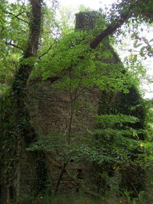
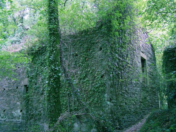
Le
moulin de Cotonard
Le moulin abandonné |
|
Ce joli
petit moulin à eau de 1844 n'est indiqué sur aucune carte. Même
l'inventaire général du patrimoine culturel de la région Bretagne
l'ignore incroyablement, lui préférant son proche voisin le moulin
du Quinquis. Je l'ai donc baptisé "moulin de Cotonard", du nom du
plus proche hameau, où se situent les haras et le centre équestre
du même nom. |
Additional Waypoints
P11ZEHB - Parking conseilléN 47° 47.356 W 003° 32.980
P21ZEHB - Cache (Box)
N 47° 47.401 W 003° 32.696
Additional Waypoints (2)
| Code | Name | Type | Links | Comments | Date | Coordinates | Distance |
| P11ZEHB | Parking conseillé | Parking Area | Google Maps | 04-10-2009 | N 47° 47.356 W 3° 32.980 | 0,36 kms W | |
| P21ZEHB | Cache (Box) | Final Location | Google Maps | 04-10-2009 | N 47° 47.401 W 3° 32.696 | 0,00 kms W |
Current at 24-06-2010
![]() 17-06-2010 by TIFOU56
17-06-2010 by TIFOU56
Un jolie coin a découvrir
![]() 21-05-2010 by Marmotte67
21-05-2010 by Marmotte67
Profite d'une virée dans le finistère pour partir à la recherche de cette géocache. Endroit très sympa.
TFTC
![]() 19-05-2010 by uli1313
19-05-2010 by uli1313
last day in finistère, loved it. TFTC uli1313
![]() 16-05-2010 by plezier42
16-05-2010 by plezier42
en vacance en Bretagne
trouvee a 14.30 h
tftc
plezier42 holland
![]() 13-05-2010 by vpkh68
13-05-2010 by vpkh68
Petite balade sur un chemin un peu boueux pour aller découvrir les ruines de ce moulin.
MPLC
#296
Nearby Caches
GC157AZ La digue (0,99 kms E)
GC1N8J0 Saint Maudez (1,86 kms SW)
GC1TWHJ Le ponton des canoës (1,86 kms NE)
GC1V419 Le moulin de Kercousquet (2,17 kms W)
GC219FM La Laïta (2,23 kms SE)
Hints (Back)
Dans la plus petite ruine, tout au fond d'un trou à l'angle des murs. / In the smallest ruin, deep in a hole in the corner of the walls.