Master Index Nearest Caches Doėlan aval by Locouarn (1,5/2)
N47° 46.330 W3° 36.470 (WGS84) UTM 30T E 454459 N 5291157 Use waypoint: GC1V2W3 Size:  Regular Hidden on 23-06-2009 Regular Hidden on 23-06-2009
In Finistčre Bretagne, France Difficulty:  Terrain: Terrain: 
*No attributes specified* Add cache to watch list Log your visit Picture Gallery |
|
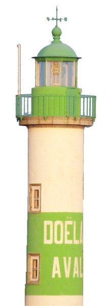
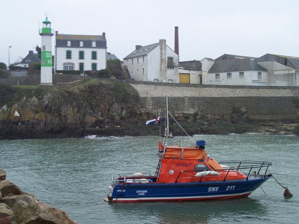
Doėlan
Aval |
|
Le petit
port de Doėlan est aussi charmant qu'universellement connu pour sa
vue du phare vert de "Doėlan aval". C'est en effet l'alignement de
ce phare vert, donc situé sur la rive gauche, avec le phare rouge
de "Doėlan amont" situé au fond du port sur la rive droite qui
définit la route ą suivre pour entrer au port. En arričre plan se
trouvent les vestiges de la conserverie Larzul, devenue "Capitaine
Cook", qui a depuis déménagé vers une zone industrielle située plus
loin de la cōte. Je vous propose de vous garer dans le parking
situé ą proximité (P1) bien qu'il existe des possibilités de
stationnement plus proches, mais plus aléatoires, surtout en
saison. |
Additional Waypoints
P11V2W3 - Parking conseillé / Parking placeN 47° 46.330 W 003° 36.470
P21V2W3 - Phare (indice) / Lighthouse (clue)
N 47° 46.327 W 003° 36.505
P31V2W3 - Cache / Box
N/S __ ° __ . ___ W/E ___ ° __ . ___
Additional Waypoints (2)
| Code | Name | Type | Links | Comments | Date | Coordinates | Distance |
| P11V2W3 | Parking conseillé / Parking place | Parking Area | Google Maps | 23-06-2009 | N 47° 46.330 W 3° 36.470 | 0,00 kms N | |
| P21V2W3 | Phare (indice) / Lighthouse (clue) | Question to Answer | Google Maps | 16-07-2009 | N 47° 46.327 W 3° 36.505 | 0,04 kms W |
Current at 24-06-2010
![]() 09-06-2010 by gdugardon
09-06-2010 by gdugardon
# 787 - En compagnie de KER-JPJ
Premičre cache de l'aprčs-midi. C'est vraiment un paysage de carte postale 
Cache suffisamment ą l'écart pour ne pas déranger les moldus.
Merci Locouarn
OUT : Rien
IN : Un soldat et une coccinelle
![]() 09-06-2010 by KER-JPJ
09-06-2010 by KER-JPJ
Belle cache ą l'abri des moldus ! en compagnie de Gdugardon.
In : une pince coccinelle
Out : rien
TFTC
![]() 23-05-2010 by Rototo
23-05-2010 by Rototo
Beaucoup de moldus en ce jour estival
En trouvant l'endroit de la cache nous avons cru qu'elle avait été vandalisé car le papier expliquant le principe du geocaching délavé par la pluie et un ziploc étaient dans l'herbe ...
Mais finalement tout va bien , la boite était bien en place.
in: stylo, marque page.
Out: bague, haltčres.
Tout a été remis en place au mźme endroit, bien camouflé.
TFTC
![]() 30-12-2009 by coutcout
30-12-2009 by coutcout
Quel bel endroit !
![]() 30-12-2009 by ysmify
30-12-2009 by ysmify
Encore un joli endroit ą découvrir.
Nearby Caches
GC159TE
GC1V419 Le moulin de Kercousquet (2,93 kms NE)
GC15VJ1 Le fortin (3,40 kms W)
GC1N8J0 Saint Maudez (3,94 kms E)
GC156Q1 Le trésor du naufragé (4,51 kms E)
Hints (Back)
Sous des buissons au bas d'un grillage / Under bushes just down a wire fence