Master Index Nearest Caches Chapelle ŕ Cléguer #01 by carlit (3/2)
N47° 52.750 W3° 22.340 (WGS84) UTM 30T E 472161 N 5302937 Use waypoint: GC1V2G3 Size:  Regular Hidden on 23-06-2009 Regular Hidden on 23-06-2009
In Morbihan Bretagne, France Difficulty:  Terrain: Terrain: 
*No attributes specified* Add cache to watch list Log your visit Picture Gallery |
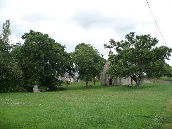
Chapelle St Guenael
Je vous propose une ballade d'environ 1 heure ŕ pieds autour de la chapelle.
Le cheminement normal ne doit pas vous amener ŕ quitter routes, chemins ou sentiers du domaine public... Respectez les propriétés privées...
Garez votre véhicule ŕ la chapelle. N47°52.750 - W003°22.340Répondez ŕ la question suivante :
Durant quel sičcle fut construite cette chapelle ? ( on notera "A" ce sičcle ).
Maintenant en avant pour la ballade....
Suivez la route au cap 110° jusqu'au WP1.
WP1 - N47°52.725 - W003°21.950
Continuez sur la route au cap nord, jusqu'au WP2.
WP2 - N47°53.xxx - W003°22.490 ( avec xxx=20A - 5 )
Ce waypoint désigne le début du sentier. Prenez ce sentier au cap
230 jusqu'ŕ la cache.
CACHE - N47°53.0yy - W003°22.zzz ( avec yy=2A + 10 et zzz=40A -5
)
La cache est du côté ouest du sentier.
Continuez ensuite ce sentier jusqu'au WP3.
WP3 - N47°52.960 - W003°22.473
Suivez le chemin qui part au sud vous arriverez ŕ la chapelle qui
est tout prčs...
Additional Waypoints
P11V2G3 - ChapelleN 47° 52.750 W 003° 22.340
S11V2G3 - Carrefour
N 47° 52.725 W 003° 21.950
S21V2G3 - Début du sentier
N/S __ ° __ . ___ W/E ___ ° __ . ___
S31V2G3 - Point de passage pour le retour
N 47° 52.960 W 003° 22.473
XX1V2G3 - Cache finale
N/S __ ° __ . ___ W/E ___ ° __ . ___
Additional Waypoints (3)
| Code | Name | Type | Links | Comments | Date | Coordinates | Distance |
| P11V2G3 | Chapelle | Question to Answer | Google Maps | 23-06-2009 | N 47° 52.750 W 3° 22.340 | 0,00 kms N | |
| S11V2G3 | Carrefour | Stages of a Multicache | Google Maps | 23-06-2009 | N 47° 52.725 W 3° 21.950 | 0,49 kms E | |
| S31V2G3 | Point de passage pour le retour | Reference Point | Google Maps | 23-06-2009 | N 47° 52.960 W 3° 22.473 | 0,42 kms NW |
Current at 24-06-2010
![]() 17-04-2010 by Tomaero
17-04-2010 by Tomaero
Jolie balade dans un coin bien tranquille, quelques vaches qui me regardent passer, le soleil au rendez-vous.
Une bien belle journée de geocaching.
Merci Carlit!
![]() 13-04-2010 by Bibega
13-04-2010 by Bibega
Aujourd’hui, c’est ma ˝ journée de liberté pour le géocaching. On me laisse la voiture et je suis libre… Alors, hop, c’est parti…
Une multi-promenade au milieu des chemins creux.. Génial. La boite est trouvée rapidement… Et hop, je file…
TFTC
(G)arp
![]() 25-10-2009 by mumbo jumbo
25-10-2009 by mumbo jumbo
Retro logging through a mileage tracking coin
![]() 07-08-2009 by janpe
07-08-2009 by janpe
An interesting chapel and a nice walk to the cache site. The cache was quickly found and the log signed. T4TC
![]() 05-08-2009 by mumbo jumbo
05-08-2009 by mumbo jumbo
(557) MJ plus 4 other family members did this on a pleasant summer afternoon. We popped into the chapel (it is nice these chapels are left open - they would be locked in the uk) and had a look around. I only just stopped my kids from ringing the bell!! Anyway, the info was easily found and the necessary calculations undertaken. We enjoyed the walk and found the cache easily. We took a toy pony figure and left a Give Peace a Chance TB (mojo bracelet). Some photos to follow...
TFTC.
mj
[This entry was edited by mumbo jumbo on Friday, August 07, 2009 at 3:27:01 PM.]
Nearby Caches
GC1TKBX
GC1X6H8 Chapelle ŕ Cléguer #02 (1,51 kms W)
GC1MB7H Moulin St Yves (4,07 kms S)
GC1WRH1 Pont Sant Yann (5,26 kms S)
GC281NW
Hints (Back)
Au pieds d'une petite souche, sous quelques rondins