Master Index Nearest Caches Punta Umbria - Los Enebrales - DP/EC21 by Daniel Oliveira (1/1)
N37° 11.105 W6° 59.048 (WGS84) UTM 29S E 678938 N 4117308 Use waypoint: GC1E2X7 Size:  Not chosen Hidden on 11-7-2008 Not chosen Hidden on 11-7-2008
In Andalucía, Spain Difficulty:  Terrain: Terrain: 
|
|


Punta Umbria –
Los Enebrales
N 37º 11.105 W 6º 59.048
Setting:
Punta Umbría is shouldered by an area covering 162 hectares of
protected beach, sand dunes and woods, including a juniper grove,
one of the few examples of this type in Andalucía. The 50-m wide
beach, with fine, golden sand, stretches for 2.3km.
The Playa (beach) de los Enebrales is bordered by a double front
of sand dunes. The most recent dunes run parallel to the sea and
are locally termed “embryonic dunes”, while the more established
ones are colonized by a grove of the eponymous enebros (juniper)
trees. Junipers are relatively rare along the Andalucian coastline.
Alongside these grow stone pines, black pines, broom, thyme,
rosemary and wildflowers.
The woodland is rich in fauna, with a variety of small mammals and
reptiles. Examples of birds here are azure-winged magpies,
nightjars, goldfinches, curlews, hoopoes and cuckoos.
The dune system:
The dune system is made up of four (4) main components or
sectors.
- Embryonic dunes – These are shifting sands with a little amount of vegetation. It is highly sensitive to human traffic and degrades very rapidly.
- Secondary dunes – This presents a larger amount of vegetation and also a larger amount of species diversity. The major destruction is caused by motorized vehicles.
- Juniper zone – Under tremendous pressure by the constantly developing and sprawling urban development. It is here that species such as chameleons are common.
- Pine land – Trees of larger stature are common as are the greater variety of bird species mentioned above.

Urban
sprawl and the rehabilitation:
Punta Umbria is
developing into the very characteristic sea-side resort that is so
characteristic along the Andaluzian coast. The area is seeing the
development of large hotel complexes that are vying for prime
location so their guest do not have to walk long distances to the
beach. This threat/pressure is impacting directly on the beautiful
dune system precariously balancing between ocean and sea-side
resorts.

 The government, through the Ministry of the
Environment, has detected this threat and is actively taking
steps to rehabilitate the dune system back to its former
glory.
One positive way in which is doing this is to provide clear,
concise information along the dune system of the
 efforts being carried out during the
rehabilitation as well as provide information on the dune
system itself: the various sectors, fauna and flora.
The second positive way in which it is fighting the impact of
human traffic along the dunes is to constrain pedestrian traffic to
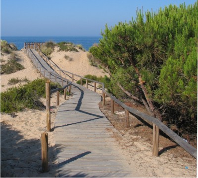
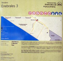
“senderos” or boardwalks. These senderos are all clearly identified
with a unique name and tell the user how long they are and the
average time it should take someone to cross it. The senderos often
have information on the local floral species.
Earthcaching in Los Enebrales:
This earthcache will take you to a set of coordinates in the
sector of the Embryonic Dune Field sector. Because this is by far
the most sensitive point of the dune system, sand retainers that
prevent the sand from blowing away have been planted at this
location in rows parallel to the sea.
In order to claim this earthcache
e-mail me with the answer to the following question: How nay rows
of sand retainers are planted at this location and what do they
look like? I will get back to you with permission to log the
cache.
This cache in no way places any one on the dunes and makes no one
leave the senderos. You can answer the simple question by walking
along the sendero.

A cache:
No local das coordenadas, que se situam no sector das dunas embrionárias, foram plantados filas de plantas que actuam como inibidores do movimento da areia evitando que seja transportada para longe. Para poderes logar esta earthcache manda-me um mail com a resposta à seguinte pergunta: Quantas filas destas plantas é que foram plantadas no local? e descreve a sua morfologia também. Assim que possível, eu enviarei autorização para logar ou não a cache. Obrigado e boa praia.

(Kindly translated by
Juan Y Maribel - Thank
you)
Punta Umbría esta flanqueada por un área protegida de 162
hectáreas de playa dunas y bosques, incluido su enebral, uno de los
pocos ecosistemas de este tipo que aún quedan en Andalucía. La
playa de 50m de ancho de dorada y fina arena, se extiende a lo
largo de 2.3 km.
La playa de los Enebrales está flanqueada por un frente doble de
dunas. Las dunas mas jóvenes corren paralelas a la linea de costa y
son conocidas como “dunas embrionarias”, mientras que las mas
maduras son colonizadas por un matorral de enebros conocido como
enebral. El enebro es relativamente raro a lo largo de la costa
andaluza.
Tas estos crecen el pino piñonero el pino negro, retama, tomillo,
romero y flores silvestres.
El bosque es rico en fauna con gran variedad de pequeños mamíferos
y reptiles. Ejemplo de las aves que podemos encontrar son la urraca
azul,(nigthjars),jilguero,zarapito la abubilla y el
cuco.
El sistema
dunar: El sistema dunar esta formado por cuatro componentes
principales o sectores.
-
Dunas embrionarias - Son arenas móviles con algo de vegetación. Son muy sensibles al trafico humano y se degradan rápidamente.
-
Dunas secundarias – Presentan un gran acumulo de vegetación ademas de una alta biodiversidad. La mayor destrucción de estas es causada por el paso de vehículos motorizados.
-
Enebral y ó Sabinal – Soporta una presión tremenda debida a la constante y exesiva presión urbanística. Es aquí donde especies como el camaleón son frecuentes.
-
Pinar – Arboles de gran estatura y gran diversidad de avifauna, como mencionábamos arriba conforman este sector.

Earthcaching
en Los Enebrales: (Kindly
translated by
J. Rover - Thank you)
Este earthcache le sitúa en el sector de dunas embrionarias del
campo. Porque éste es en gran medida el punto más sensible del
sistema de la duna, los detenedores de la arena que evitan que ésta
sople lejos se han plantado en esta localización en filas paralelas
al mar. Para demandar este earthcache envíeme un E-mail con la
respuesta a la pregunta siguiente:
¿Cuántas filas de de detenedores de
arena se han plantan en esta localización y a qué se
parecen? Yo le contestaré con el permiso de
registrar el cache.
Para realizar este cache no es necesario entrar de ningún modo en
las dunas y ni salir de las marcas. Usted puede contestar a la
pregunta simplemente caminando a lo largo del sendero.

 The most exciting way to learn about the Earth
and its processes is to get into the outdoors and experience
it first-hand. Visiting an Earthcache is a great outdoor
activity the whole family can enjoy. An Earthcache is a
special place that people can visit to learn about a unique
geoscience feature or aspect of our Earth. Earthcaches include
a set of educational notes and the details about where to find
the location (latitude and longitude). Visitors to Earthcaches
can see how our planet has been shaped by geological
processes, how we manage the resources and how scientists
gather evidence to learn about the Earth. To find out more
click HERE.
______________________________________________________________________________