Master Index Nearest Caches La Chaise du Diable by njda78 (3/3)
N47° 51.225 W3° 12.876 (WGS84) UTM 30T E 483947 N 5300068 Use waypoint: GCXKPJ Size:  Regular Hidden on 09-09-2006 Regular Hidden on 09-09-2006
In Morbihan Bretagne, France Difficulty:  Terrain: Terrain:
*No attributes specified* Add cache to watch list Log your visit Picture Gallery |
| |
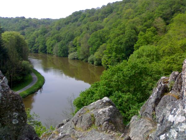
La cache est située sur un site d'escalade. Vous pouvez y accéder par la route ou en canoë-kayak
Pas besoin de matériel d'escalade, mais il y a un chemin rocailleux ŕ prendre pour trouver la cache final.
- Pour accéder ŕ la cache par la route : prendre le
WP du parking.
- Pour accéder ŕ la cache par l'eau : il y a des locations de canoë, kayak ou autres, ICI. Je conseille de partir de ce WP.
Le parcours se constitue d'une premičre cache qui vous dévoilera les coordonnées de la deuxičme et derničre cache.
Vos photos sont les bienvenues!!!
Pour toute question, vous pouvez m'envoyer un e-m@il!!!
The hiding place is located on the commune of INZINZAC-LOCHRIST on border of Blavet's river.
The hiding place is located on a site of climbing. You can reach it by the road or by canoë-kayak. Not need for material of climbing, but there is a rocky way has to take to find the final hiding place.
- To reach the hiding place by the road : take the
WP of the car park.
- To reach the hiding place by water : there is hiring of canoë-kayak or others, HERE. I advise to start from this WP.
The trip is maked of a first hiding place, which will reveal you the co-ordinates of the second and last hiding place.
For any question, send me an e-m@il!!!


Additional Waypoints
CPXKPJ - Car ParkN 47° 51.242 W 003° 12.965
DPXKPJ - Départ Canoé-Kayak
N 47° 51.225 W 003° 12.860
Additional Waypoints (2)
| Code | Name | Type | Links | Comments | Date | Coordinates | Distance |
| CPXKPJ | Car Park | Parking Area | Google Maps | 09-08-2006 | N 47° 51.242 W 3° 12.965 | 0,11 kms W | |
| DPXKPJ | Départ Canoé-Kayak | Reference Point | Google Maps | 11-08-2006 | N 47° 51.225 W 3° 12.860 | 0,02 kms E |
Current at 24-06-2010
![]() 28-07-2009 by plonge29
28-07-2009 by plonge29
Jolie cache trouvée ŕ l'arrachée, sans avoir trouvé les coordonnées en haut du rocher. trčs joli site d'escalade qui donne envie, nous aurions dű prendre nos cordes et nos baudards... .
merci encore
PLONGE29
![]() 25-07-2009 by lovekraft
25-07-2009 by lovekraft
belle vu sur le premier WP
![]() 17-07-2009 by wimpieke
17-07-2009 by wimpieke
We had some trouble to get the the start location: after trying various roads though, we eventually were able to locate the parking site. The micro on WP1 took some time, especially since the leader was a bit anxious on the conditions on WP1. Fearless member Daniel had less problems though and found the micro. Nothing was stopping us now and cache was easily found. Nice place.
![]() 28-05-2009 by ClockworkBruce
28-05-2009 by ClockworkBruce
SatNav couldn't find the start co-ordinates for cars - so we got completely off course - but the view of the quarry lake was nice. Found the general area of the first cache finally but ran out of time - one for another day. B) Google maps on my iPhone reckons the Car Park co-ordinates are N47° 51' 14.26", W3° 12' 58.10"
![]() 31-10-2008 by yandens
31-10-2008 by yandens
Deuxičme tentative, mais celle-ci sera la bonne.
Alors que la fois derničre nous avions tourné plusieurs dizaines de minutes sans męme trouver la micro, celle-ci sera trouvée en tout juste deux minutes cette fois-ci. On longe le Blavet, et la cache finale ne fera elle non plus pas long feu.
Trčs belle endroit, merci beaucoup pour cette petite balade.
In : figurine
Out : TB
Nearby Caches
GC12KWX La Fontaine de Saint Urlo (1,96 kms SE)
GC100PB Les Chevaux #02 (2,25 kms SW)
GC12KX4 La Glissiere (3,64 kms SW)
GC1D9E4 Lavoir #04 : Lochrist (4,36 kms SW)
GC1C4ZG La Cascade de Ty Neüé (4,57 kms SW)
Hints (Back)
- Les caches se trouve sur la rive droite quand on
descends le fleuve!!!!
- Pour trouver la cache final, il faut descendre vers l'eau. Elle se trouve entre deux rochers, au pied des fougčres.
---------------------------------------------------------------------
- Hiding places is on the right bank when you Going down the river!!!!
- To find the final hiding place, it is necessary to come down towards the water. Between two rocks, at the feet of a plant.