Master Index Nearest Caches Event Finistérien "Le Champignon" by Soad29 (1,5/1,5)
N48° 22.123 W3° 44.916 (WGS84) UTM 30U E 444557 N 5357554 Use waypoint: GC1VAA7 Size:  Not chosen Hidden on 29-06-2009 Not chosen Hidden on 29-06-2009
In Finistère Bretagne, France Difficulty:  Terrain: Terrain: 
*No attributes specified* Add cache to watch list Log your visit Picture Gallery |
| This cache is easy to realize. |

|
Event de la forêt enchantée : Le Champignon |

|

English
Huelgoat is popular with tourists and holidaymakers due to its impressive natural setting among the vestiges of the ancient forest that once covered inland Brittany. Once part of royal and ducal lands, the forest is now overseen by the French forestry commission, the National Forests Office. It has an area of 10 square kilometres. A large replanting scheme has repaired much of the damage sustained by the forest in storms on the 15-16 October 1987, when 3.1 square kilometres of trees were levelled or damaged. The village lies on a lake created between the 16th and 18th centuries to supply water to local silver-lead mines by means of a 3 km (1.9 mi) leat or canal. A number of geological and prehistoric curiosities can be found by following trails in and around the village and forest.
The geological explanation of Huelgoat: these rocks come from the depths of the ground. Born with ten km of depth in the form of liquid masses in fusion, these masses will go up very slowly towards surface, will cool and be solidified with a few kilometers of the level of the ground. Then erosion, i.e. the rainwater and the streaming, freezing, heat will contribute to release, clear all the ground surmounting these rocks; it is thus released which one finds them today.
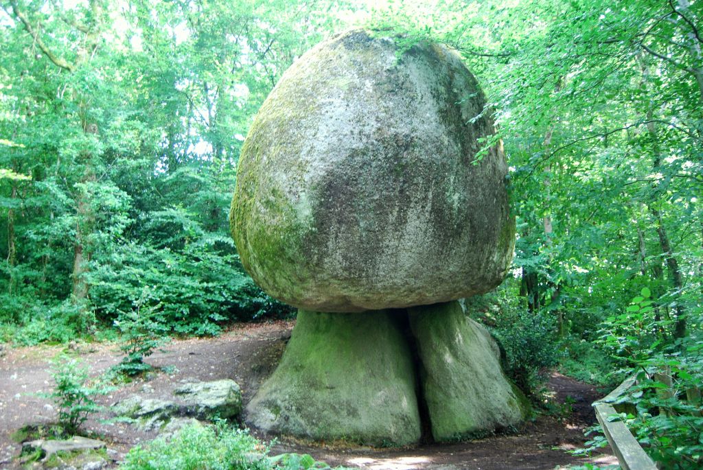
Among these are: « Le Champignon”, or The Mushroom, is a large rock balanced on a smaller one to give the eponymous appearance. To log this EarthCache you must photograph yourself or your GPS with the Mushroom, then you must estimate the approximate height of the rock“Le Champignon”. Email your answer and your photo to me via the profile. When you receive a confirmatory reply you may log the cache and include your photograph with the log.
Français
Les rochers de Huelgoat
Ces rochers viennent des profondeurs de la terre. Nées à un dizaine de km de profondeur sous forme de masses liquides en fusion, ces masses vont remonter très lentement vers la surface, vont se refroidir et se solidifier à quelques kilomètres sous le niveau du sol. Puis l'érosion, c’est-à-dire les eaux de pluie , le ruissellement, le gel et la chaleur vont contribuer à dégager, à déblayer tout le terrain surmontant ces roches ; c'est ainsi dégagées qu'on les retrouve aujourd'hui.
Pour vaider votre log, il vous faudra m'amener par mail, via mon profil une photo de vous, ou de votre gps, devant le champigon, en répondant à la question suivante: "quelle est la hauteur approximative de ce rocher?"
Additional Waypoints
011VAA7 - ParkingN 48° 22.097 W 003° 44.944
Additional Waypoints (1)
| Code | Name | Type | Links | Comments | Date | Coordinates | Distance |
| 011VAA7 | Parking | Parking Area | Google Maps | 30-07-2009 | N 48° 22.097 W 3° 44.944 | 0,06 kms SW |
Additional Hints (There are no hints for this cache)
Current at 24-06-2010
![]() 17-05-2010 by Danbike_Lizbike
17-05-2010 by Danbike_Lizbike
Bonne promenade et jolie environ. Merci Thanks for the cache.
![]() 11-05-2010 by vpkh68
11-05-2010 by vpkh68
Pour terminer la journée, un petit détour par ce champignon avant d'aller en acheter des vrais en face 
Le rocher est vraiment surnaturel, merci pour cette belle découverte.
#293
![]() 07-05-2010 by De Riempjes
07-05-2010 by De Riempjes
Yeah, our number 750! We started geocaching in France and now we found our, probably, 750st one in the forrest of Huelgoat.
Still waiting on the results of two ´eartcaches´, but we have already celebrated this one!
Today we drove from Lanloup to Huelgoat. Nine years ago we visited this region and today we did it again.
We planned a nice trail and found all of the 15 caches. Two 'earth ones' and this was one of them.
We started the hike in the rain and we have ended in it. In spite of that, we had a lot of fun and enjoyed the walk through the forrest. This is such a nice place to be! The huge, weird rocks, the heights, different colours, no people and a lot of hidden boxes!
This was the last one of our hike. A beautiful ´Champignon´!
At the place to be, we saw why this one became an ´earthcache´.
Thanks or showing us this place and this beautiful rock and for our number 750, ofcourse  !
!
Kind regards from team ´De Riempjes´.
![]() 06-05-2010 by Hobo and Miss
06-05-2010 by Hobo and Miss
An interesting formation which we have not visited before. Thank you for taking us to it.
We will post our photos when we return home to England.
Merci beaucoup pour la cache.
![]() 15-03-2010 by gwenadu
15-03-2010 by gwenadu
2ème station le champignon, je ne connaissais pas : assez surprenant. Petit tour à Inter pour acheter les piles pour la lampe frontale pour la grotte du diable.
Nearby Caches
GC11389 Logan or Rocking Stones - 'La Roche Trem (0,30 kms SE)
GC1V1X3 Event de la forêt enchantée : le chemin (0,34 kms NE)
GC1RH2R Event forêt enchantée : la grotte du dia (0,37 kms SE)
GC1RH3E
GC1RH3Q Event de la forêt enchantée : Huelgoat (0,50 kms SW)
Additional Hints (There are no hints for this cache)