Master Index Nearest Caches kerloas le géant de granit by bob29 (1,5/1,5)
N48° 25.596 W4° 40.758 (WGS84) UTM 30U E 375770 N 5365079 Use waypoint: GC19GTJ Size:  Not chosen Hidden on 19-02-2008 Not chosen Hidden on 19-02-2008
In Finistère Bretagne, France Difficulty:  Terrain: Terrain:
*No attributes specified* Add cache to watch list Log your visit Picture Gallery |
 |
La Bretagne terre des
mégalithes :
Riche et diversifié, le
patrimoine archéologique breton est surtout connu pour ses
monuments mégalithiques. Edifiés au
néolithique, les imposants menhirs se dressent par milliers
sur certains sites bretons : lieux de sépulture ou de
rassemblement, points de repères astronomiques ou bornes
marquant la séparation entre deux mondes? Leur signification
demeure incertaine, de même que la façon de les
aborder. Beaucoup reste à
découvrir……
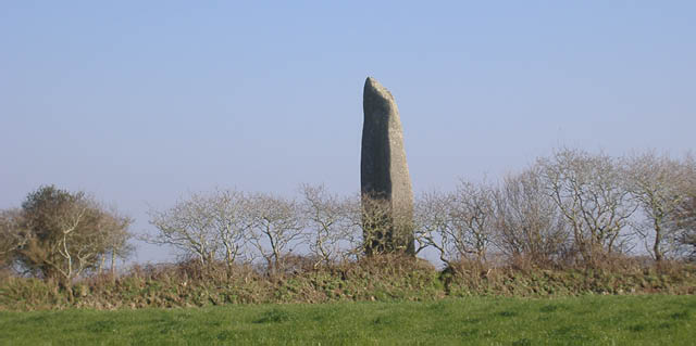
Kerloas, le plus haut bien
que décapité :
Il s’agit du menhir (terme construit à partir du
breton maen, « pierre », et hir, « longue
») le plus grand actuellement debout.
Géologie et
histoire :
La roche
constituant le menhir de Kerloas est un granite porphyroïde
à très gros feldspaths roses (orthoses
essentiellement) et micas noirs (biotites). ce granite qui comporte
des petites enclaves endogènes allongées de teinte
gris-noir, à grain fin, est connu sous le nom de granite de
l'Aber-Ildut. Ce granite est réputé pour sa couleur
rosée (due à la présence de particules
microscopiques d'hématite dans les orthoses), et sa
résistance à l'altération.
Détail du granite de l'Aber
Ildut : Il a servi à la construction de phares, de
bâtiments publics ou privés, de forts et, en 1835, on
l'utilisa pour former le socle de l'obélisque de Louqsor
à Paris.
Au Néolithique, la plupart des mégalithes (dolmens et
menhirs) de la région de Porspoder ont été
construits avec cette roche.
La carte géologique révèle que le substratum
du site d'implantation du Menhir de Kerloas est formé par le
granite de Saint-Renan, granite à grain fin au sein duquel
existent des formations stanno-wolframifères.
L'érosion de ce granite est à l'origine des
gîtes alluvionnaires de cassitérite (minerai
d'étain).
L'affleurement de granite de l'Aber Ildut le plus proche de Kerloas
est distant de 2 km et il est raisonnable de penser que les hommes
du Néolithique ont transporté le bloc sur une
distance de plusieurs kilomètres, ce qui ne fut sans doute
pas une mince affaire.
Caractéristiques :
Sa hauteur
au-dessus du sol naturel est de 9,50 m. En effet il faut faire
abstraction de 0,30 m de terre rapportée, il y a quelques
années, pour pallier l'érosion du sol
provoquée par le piétinement des visiteurs. Cette
érosion avait eu pour effet de mettre au jour les pierres de
calage du menhir.
Cependant, la hauteur originelle de ce monolithe était bien
plus importante et devait dépasser les 10 m car, au
XVIIIème siècle, il fut victime de la foudre qui en
tronqua la partie sommitale et les principaux morceaux qui gisaient
à son pied furent utilisés, l'un pour la fabrication
d'une auge, l'autre comme pierre d'entrée de champ. Cette
dernière a été reconvertie aujourd'hui en
ornement de pelouse à la ferme voisine.
La
circonférence du menhir, au niveau du sol, est de 6,20 m ;
à 1,20 m de hauteur elle est de 6,70 m ; à 3,65 m
elle est de 6,96 m, puis la pierre devient plus fine ; à 5
m, la circonférence est de 6,45 m et à 6 m elle passe
à 5,95 m.
Le poids du menhir est estimé à 150
tonnes.
Légendes :
Sous son pied
un trésor serait caché, visible uniquement pendant la
nuit de Noël….
La légende dit qu’au premier coup de minuit, les
menhirs couraient s’abreuver dans l’océan. Mais
lorsque sonnait le douzième coup ils avaient
déjà repris leur place, stoïques, immobiles,
insensibles aux attaques du temps. Malheurs aux imprudents qui,
éblouis par les richesses dévoilées, avaient
oublié l’heure, ils étaient
écrasés…
Validation :
Pour valider
votre découverte vous devrez joindre une photo de vous ou de
votre GPS devant le menhir et m'adresser un mail indiquant ce que masque le carré rouge sur
le panneau descriptif (que vous ne pouvez manquer) sur la
photographie N°1.
Beaucoup plus de détails sur kerloas sur la page web dédiée figurant en haut du listing et dont je me suis inspiré. http://www.wiki-brest.net/index.php/Menhir_de_Kerloas
Kerloas, the granite giant.
Brittany is in hiding megaliths:
Rich and diversified, the Breton
archaeological patrimony is especially known for its megalithic
monuments. Built in the neolithic, the impressive menhirs raise
themselves(draw up themselves) by thousands on certain Breton
sites: places of grave or assembling, astronomical landmarks or
borders marking the separation between two worlds? Their meaning
remains vague, as well as the way of approaching them. A lot rest
to be discovered …
Kerloas, the highest although
beheaded:
It is about the menhir (term builds
from the Breton maen , "stone", and hir, "long") the biggest at
present up.
Geology and history:
The cliff establishing(constituting)
the menhir of Kerloas is a granite porphyroïde in very big
pink feldspars (orthoses essentially) and black micas biotites ).
This granite which contains small endogenous enclaves
lengthened(stretched out) by tint grey-black, in fine grain(bead),
is known under the name of granite of Aber-Ildut. This granite is
considered as its pinkish colour (due to the presence of tiny
particles of hématite in orthoses), and its resistance in
the change.
Detail of the granite of Aber Ildut: he(it) was of use to the
construction of lighthouses, of public or private buildings(ships),
strong and, in 1835, we used him(it) to form the pedestal of the
obelisk from Louqsor to Paris.
In the Neolithic, most of the megaliths (dolmens and menhirs) of
the region of Porspoder were built with this cliff.
The geologic card reveals that the substratum of the site of
setting-up(establishment) of the Menhir of Kerloas is formed by the
granite of Saint-Renan, the granite with fine grain(bead) within
which exist stanno-wolframifères formings(trainings). The
erosion of this granite is at the origin of shelters alluvionnaires
of cassitérite (ore of tin).
The emergence of granite of Aber Ildut the closest to Kerloas is
distant from 2 km and it is reasonable to think that the
men(people) of the Neolithic transported the block on a distance of
several kilometres, what was not doubtless a small
matter.
Characteristics:
His(Her,Its) height over the natural
ground is 9,50 m. Indeed it is necessary to disregard 0,30 m of
brought back(reported) earth(ground), some years ago, to mitigate
the erosion of the ground provoked by the standing about of the
guests. This erosion had had the effect of bringing to light stones
of wedging of the menhir.
However, the original height of this monolith was more important
and had to exceed 10 m because, in the XVIIIth century, he was a
victim of the lightning who truncated the sommitale part(party) and
the main fragments which gisaient in his(her,its) foot were used,
the one for the manufacture of an auge, the other one as the stone
of entrance(entry) of field. This last one was reconverted to
ornament of lawn to the firm neighbour today.
The circumference of the menhir, at ground level, is 6,20 m; in
1,20 m of height she(it) is 6,70 m; in 3,65 m she(it) is 6,96 m,
then the stone becomes finer; in 5 m, the circumference is 6,45 m
and in 6 m it pass in 5,95 m.
The weight of the menhir is estimated at 150 tons.
Legends:
Under its foot a treasure would would
been hidden, visible only during the night of Christmas.
The legend says that in the first blow of midnight, menhirs
ran(roamed) to drink in the ocean. But when the twelfth blow rang
they had already resumed their place, stoical, immovable,
insensible in the attacks of time. Misfortunes to the foolhardy
persons who, dazzled by the revealed wealth, had forgotten the
hour, they were crushed …
Validation :
To validate your discovery you will
have to join a photo of you or your GPS in front of the menhir and
send me a mail indicating what masks the red square on the
descriptive panel (that you cannot miss) on the photography
N°1.
Many more details of kerloas on the dedicated web page appearing in
the top of the listing and by which I was inspired.
http://www.wiki-brest.net/index.php/Menhir_de_Kerloas
| I am a proud |
 |